Khorat Geopark and Geological feature
อุทยานธรณีโคราชและลักษณะทางธรณีวิทยา
Khorat Geopark
อุทยานธรณีโคราช หรือโคราชจีโอพาร์ค
Khorat Geopark is located in north-east of Thailand with the total area of 3,167.38 square kilometer covering 5 districts in Nakhon Ratchasima: Sikhio, Sung Noen, Kham Thale So, Mueang Nakhon Ratchasima and Chaloem Phra Kiat. Khorat Geopark has 25 geosites with, 10 natural and cultural sites. Geological feature is sandstone Cuesta in south-west, rolling plain in the north, central and south and plain in north-east with Lam Takhong as the major river that confluents with the Mun river in Chaloem Phra Kiat District. It has been the location of pre-historic community with the largest variety of genera of ancient elephant fossils in the world (Khorat Geopark Office 2020a).
อุทยานธรณีโคราชตั้งอยู่ภาคตะวันออกเฉียงเหนือของประเทศไทย พื้นที่ทั้งหมด เท่ากับ 3,167.38 ตารางกิโลเมตรครอบคลุมพื้นที่ 5 อำเภอของจังหวัดนครราชสีมา ประกอบด้วย อำเภอสีคิ้ว อำเภอสูงเนิน อำเภอขามทะเลสอ อำเภอเมืองนครราชสีมา และอำเภอเฉลิมพระเกียรติ มีแหล่งธรณีวิทยา 25 แห่ง แหล่งท่องเที่ยวทางธรรมชาติและวัฒนธรรม 10 แห่ง มีลักษณะภูมิประเทศเป็นเทือกเขาเควสตาหินทรายทางด้านตะวันตกเฉียงใต้ ที่ราบลูกคลื่นทางตอนเหนือ กลางและใต้ และเป็นที่ราบลุ่มทางด้านตะวันออกเฉียงเหนือมีลำตะคองเป็นแม่น้ำสายหลัก ไหลผ่านกลางพื้นที่ไปบรรจบกับแม่น้ำมูลในอำเภอเฉลิมพระเกียรติ เป็นสถานที่ตั้งชุมชนมาแต่ครั้งก่อนประวัติศาสตร์จนถึงปัจจุบัน และเป็นแหล่งซากช้างดึกดำบรรพ์หลากหลายสกุลสุดในโลก
The area originated from sediment carried by river for more than 150 million years ago, along with a group of dinosaurs and contemporary animals fossils. When the land was uplifted into a plateau, the cuestas formation occurred. The mountains were eroded from the stream and a magnificent pre-historic geographical view was originated. At present, this area is the north east and Indochina Gateway with transportation, industry trade and tourism hub. This Khorat Geopark area is considered and names as “Cuesta and Fossil Land”. Picture 1.1 illustrates Khorat Geopark “Cuesta and Fossil Land”
พื้นที่เริ่มต้นมาจากการตกทับถมตัวของตะกอนแม่น้ำมากกว่า 150 ล้านปีก่อน พร้อมกับฝูงไดโนเสาร์และสัตว์ร่วมสมัย จนถึงยุคสัตว์เลี้ยงลูกด้วยนมที่หลากหลาย เมื่อแผ่นดินยกตัวขึ้นเป็นที่ราบสูงพร้อมกับการคดโค้งโก่งตัวและแอ่นตัวน้อยๆ ของแผ่นดินทำให้เกิดเทือกเขาเควสตารอบแอ่งโคราช ขุนเขาถูกกัดกร่อนเป็นช่องเขาน้ำกัดโดยกระแสน้ำไหลที่มีมาก่อน เกิดเป็นภูมิทัศน์ที่งดงามและมีผู้คนมาตั้งถิ่นฐานตั้งแต่ยุคก่อนประวัติศาสตร์ ต่อเนื่องมาจนถึงปัจจุบันและเป็นประตูสู่แดนอีสานและอินโดจีน รวมทั้งเป็นศูนย์กลางการคมนาคม ขนส่ง อุตสาหกรรม การค้า และการท่องเที่ยว และอาจเรียกได้ว่าโคราชจีโอพาร์คเป็น “ดินแดนแห่งเควสตาและฟอสซิล” รูปที่ 1.1 แสดงพื้นที่โคราชจีโอพาร์คดินแดนแห่งเขาเควสตาและฟอสซิล
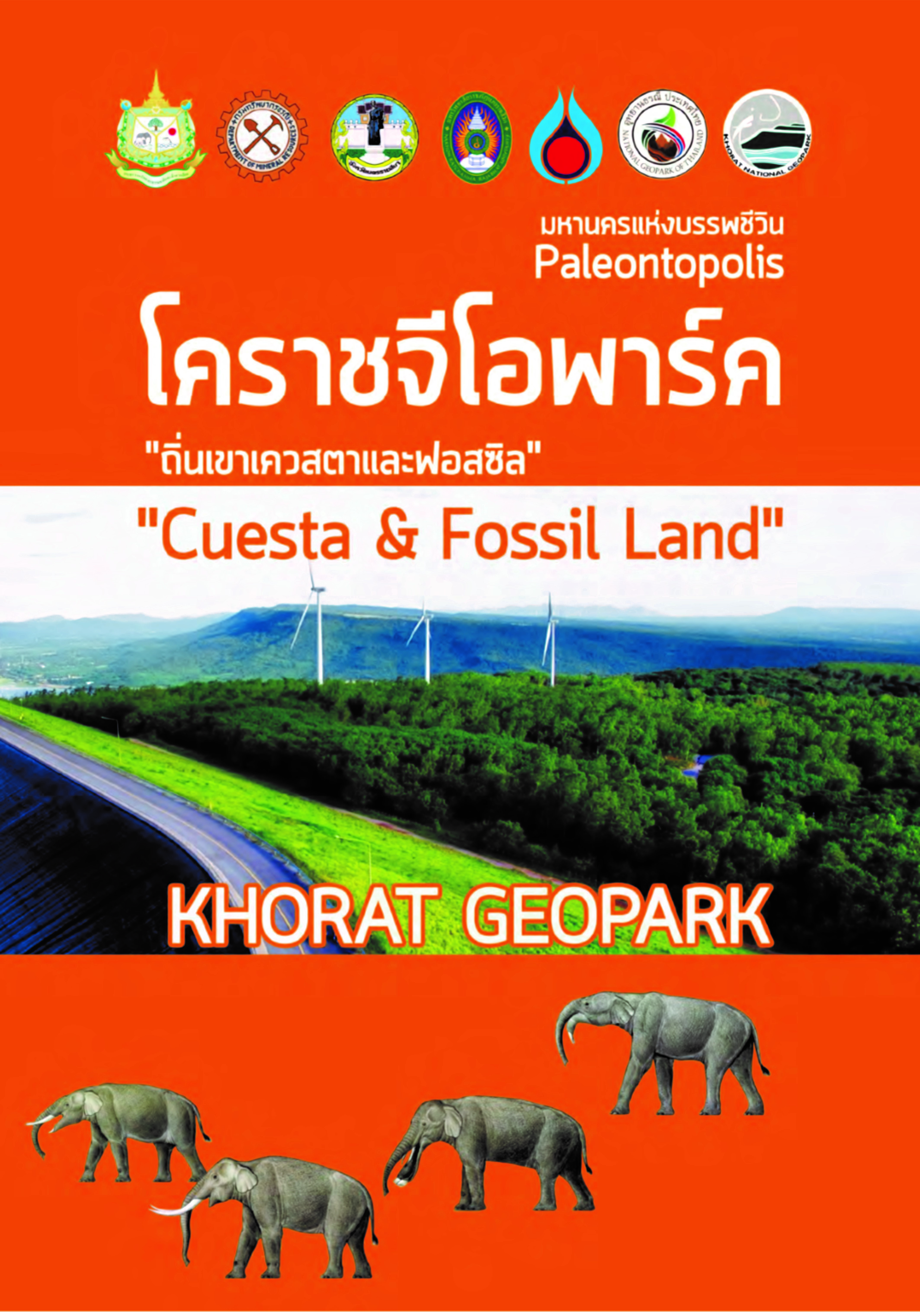
Picture 1.1: Khorat Geopark “Cuesta and Fossil Land”.
Source: Khorat Geopark Office. 2020a
Geological feature of Khorat Geopark ลักษณะทางธรณีวิทยาของโคราชจีโอพาร์ค
Khorat Geopark area is underlain by the red Mesozoic sediment rocks (dinosaur age, about 66-150 million years ago) of Khorat Group that consists mostly of sandstone with a thickness of about 4,000 meters thick. Approximately 50 million years ago, the collision of tectonic plates caused the rock layers of Khorat Group to be folded into the Khorat Basin and to be uplifted to form a plateau. Because of differences in resistance, older lower rock layers have been exposed, giving rise to geomorphological structure known as cuestas, such as Khao Yai Thiang and Khao Sap Pradu.
พื้นที่โคราชจีโอพาร์ครองรับด้วยชั้นหินตะกอนสีแดงในยุคไดโนเสาร์ที่หนาราว 4,000 เมตร ซึ่งจัดอยู่นกลุ่มหินโคราช ส่วนใหญ่เป็นหินทราย มีอายุอยู่ในช่วง 150-66 ล้านปีก่อนและประมาณ 50 ล้านปีก่อน เกิดการชนกันของเปลือกโลกทำให้ชั้นหินชุดโคราชคดโค้งเป็นแอ่งโคราชพร้อมกับการยกตัวเป็นที่ราบสูงทำให้ชั้นหินที่มีอายุเก่ากว่าโผล่ขึ้นมาเกิดเป็นสัณฐานภูมิประเทศแบบเขาอีโต้หรือเขาเควสตา (Cuesta) เช่น เขายายเที่ยง เขาซับประดู่
Lam Takhong is an antecedent river because it flowed through the area of geopark before the rise of the cuestas. When the land was uplifted the Lam Takhong and tributaries eroded deeply through rock layers. However, rocks of Phra Wihan and Phu Phan formations are more resistant and remain as 2 ridges of cuestas. During the major uplift 800,000 years ago, there was erosion taking cuesta sediments to nearby areas with sediment, plant and animal fossils to form a terrace with fossil wood from Sung Noen to Kham Thale So to Mueang to Chaloem Phra Kiat Districts. Picture1.2 illustrates Khorat Cuesta Formation.
ลำตะคองเป็นธารน้ำบรรพกาลอยู่ในพื้นที่จีโอพาร์คก่อนเกิดภูมิประเทศเควสตา เมื่อมีการยกตัวเป็นที่ราบสูงลำตะคองไหลกัดเซาะในทางลึก หมวดหินพระวิหาร และหมวดหินภูพานที่ทนทานแข็งแกร่งว่าหมวดหินอื่นจึงเหลือเป็นสันเขาเควสตา หรือเขารูปอีโต้สองสัน เมื่อมีการยกตัวครั้งสำคัญล่าสุดเมื่อกว่า 800,000 ปีก่อน เกิดการกัดเซาะชองลำน้ำนำพาตะกอนจากเขาเควสตาและพื้นที่ไกล้เคียงไปทับถมเป็นตะกอนกรวดทราย พร้อมชิ้นส่วนซากดึกดำบรรพ์พืชสัตว์หลายชนิดหลายอายุ รวมถึงเนินตะพัก และไม้กลายเป็นหิน จาก อ.สูงเนิน-ขามทะเลสอ-เมืองนครราชสีมา-เฉลิมพระเกียรติ ดังรูปที่ 1.2 แสดงการเกิดเควสตาโคราช
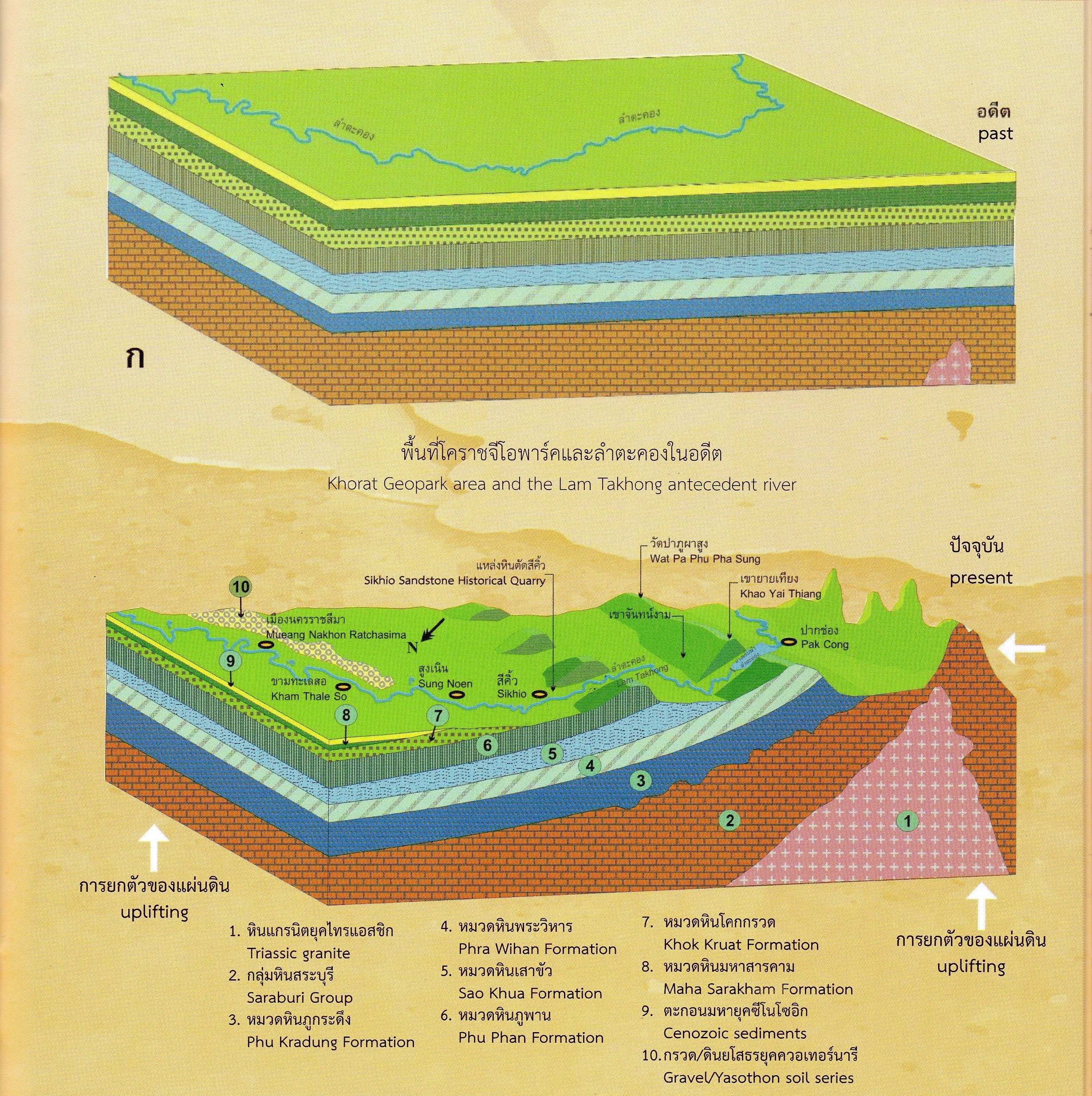
Picture 1.2: Khorat Cuesta Formation
Source: Khorat Geopark Office. 2020a
Khorat Geopark is the land of Cuesta covering two major types of Cuesta: Phra Wiharn Formation Cuesta and Phu Phan Formation Cuesta.
Phra Wiharn Formation Cuesta covers Khao Kanan Chit Cuesta, Khao Yai Thiang Cuesta, Khao Nam Dot Khao Mak Cuesta and Phu Pha Sung Cuesta.
Phu Phan Formation Cuesta covers Khao Pha Cuesta, Khao Kradon Cuesta, Khao Sam Sib Sang Cuesta, Phu Saen Dao Cuesta (Khao Ta Guid), Khoa Phrik Cuesta, Khao Puen Taek Cuesta and Khao Khiao Cuesta.
พื้นที่โคราชจีโอพาร์คซึ่งถือเป็นดินแดนแห่งเขาเควสตาประกอบด้วยเควสตาหมวดหินหลักคือ เควสตาหมวดหินพระวิหารและเควสตาหมวดหินภูพาน
เควสตาหมวดหินพระวิหารประกอบด้วย เขาขนานจิต เขายายเที่ยง เขาน้ำโดด เขาหมาก และภูผาสูง
เควสตาหมวดหินภูพานประกอบด้วย เขาผา เขากระโดน เขาซับประดู่ เขาสามสิบส่าง ภูแสนดาว ( เขาตะกึด) เขาพริก เขาปืนแตก และเขาเขียว